

The Terrain Tools panel provides a comprehensive set of commands for creating, analysing, and modelling site topography within Artisan. These tools enable users to place and manage existing and proposed levels, interpolate elevations, generate contours, and create three-dimensional terrain surfaces directly from level data.
Terrain Tools support a wide range of site design and grading workflows, allowing designers to accurately represent existing ground conditions and develop proposed landscape forms. Levels can be entered manually, calculated by interpolation, or imported from external files, providing flexibility when working with survey information and design data.
Using the terrain modelling features, users can automatically generate major and minor contours from level points, apply contour annotations, and create 3D terrain surfaces for visualisation and design development. These intelligent tools help maintain consistency between level information, contours, and surface models throughout the project lifecycle.
Additional functionality is available for advanced terrain workflows, including the creation of terrain surfaces from selected levels and, where supported, projecting boundaries onto TIN surfaces to generate 3D solids for detailed modelling and construction-related tasks.
This section explains each Terrain Tools command and provides guidance on creating accurate topographic models, managing elevation data, generating contours, and producing terrain-based design information within AutoCAD, BricsCAD, and compatible environments.
Command
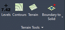
The Terrain Tools panel gives access to commands for placing and interpolating levels, dynamically creating contours and generating 3D terrains from levels.
Terrain Tools commands are available from Artisan ribbon.
Purpose
Users are able to place existing and proposed levels, interpolate levels and import levels from an external file; place and annotate major and minor contours; create a terrain from selected levels in the drawing. There is also a 'Boundary to Solid' tool that projects a boundary on to a TIN surface and then creates a solid - this tool is only available in Autodesk Civil 3D©.
Usage
Levels - Place Existing and Proposed Levels; Interpolate Levels; Import Levels from File.
Contours - Place Major and Minor Contours; define Intervals; Annotate Contours
Terrain - Create poly face mesh surface from selected level points.
Boundary to Solid - Project a boundary onto a TIN (Triangulated Irregulat Network) and create a solid of a defined thickness (this tool is only available in Autodesk Civil 3D©).